Patagonia has always called my name. I’m a mountain person. Don’t get me wrong, I love the beach, but I much prefer a good hike in the mountains. Just seeing mountains with their snow caps in the distance makes my heart warm. One of the main reasons I moved to Portland, Oregon was for that beautiful sightline of Mount Hood in the distance. I’ve lived in Oregon for seven years and I still get butterflies in my stomach everytime the horizon is clear and I can see Mt. Hood. It is like an old friend come to comfort me on a hard day. So, Patagonia and its majesticly rugged landscape, full of mountains have been calling my name for quite a while now.
Patagonia traverses two countries, Argentina and Chile, and stretches from the lowest point of the continent north to the lake regions of both countries. It is vastly untouched and a beacon for outdoor enthusiasts. The most popular time of year to visit these rugged parts is during the Northern Hemisphere’s winter from late December to the end of February, which is the Southern Hemisphere’s summer. The timing of our trip landed us in Patagonia at the tail end of winter and early spring, which came with its own benefits and challenges, but was well worth it.
My research told me that late September and October could be really beautiful in Patagonia as the hibernation of winter givesway to the rebirth of spring. So, I felt confident that we would be okay. Turns out we were just a few weeks too early for that great primavera wild flower rebirthing. Instead, we arrived in Ushuaia, the southernmost island of Patagonia on the Argentina side, during a snow storm. All of the majestic mountains donned their white caps as we made our rocky landing into the little airport at the end of the world, as they call it.
Winter in Patagonia carries its own unique appeal. For winter sport enthusiasts, there are ski slopes to visit and dog sleds to ride. The air is crisp and the mountains glisten with fresh snow. If you visit from mid-October on, you can see the penguins that adorn every store front and souvenir in the flesh. They journey up from Antartica to visit Patagonia and they are a main feature of a great majority of the tourist tours in the area. We sadly came too early for the Penguins though. Winter and early spring also bring lower prices and less crowded towns. This makes it easier to afford this very expensive part of South America if you are on a budget.
We followed the most popular route through Patagonia and despite visiting during the shoulder season, we still were able to experience some spectacular things. Here are some highlights from our tour through Patagonia during the late days of winter and early spring:
Ushuaia, Argentina:
We arrived on September 16th, a week before the spring equinox in the south. As the plane landed on the small airstrip of the southernmost island, the puffy white clouds gave way to jagged white-capped mountains. The air was frigid and snow flurries drifted down from above. We were at the end of the world, the lowest point on the continent.
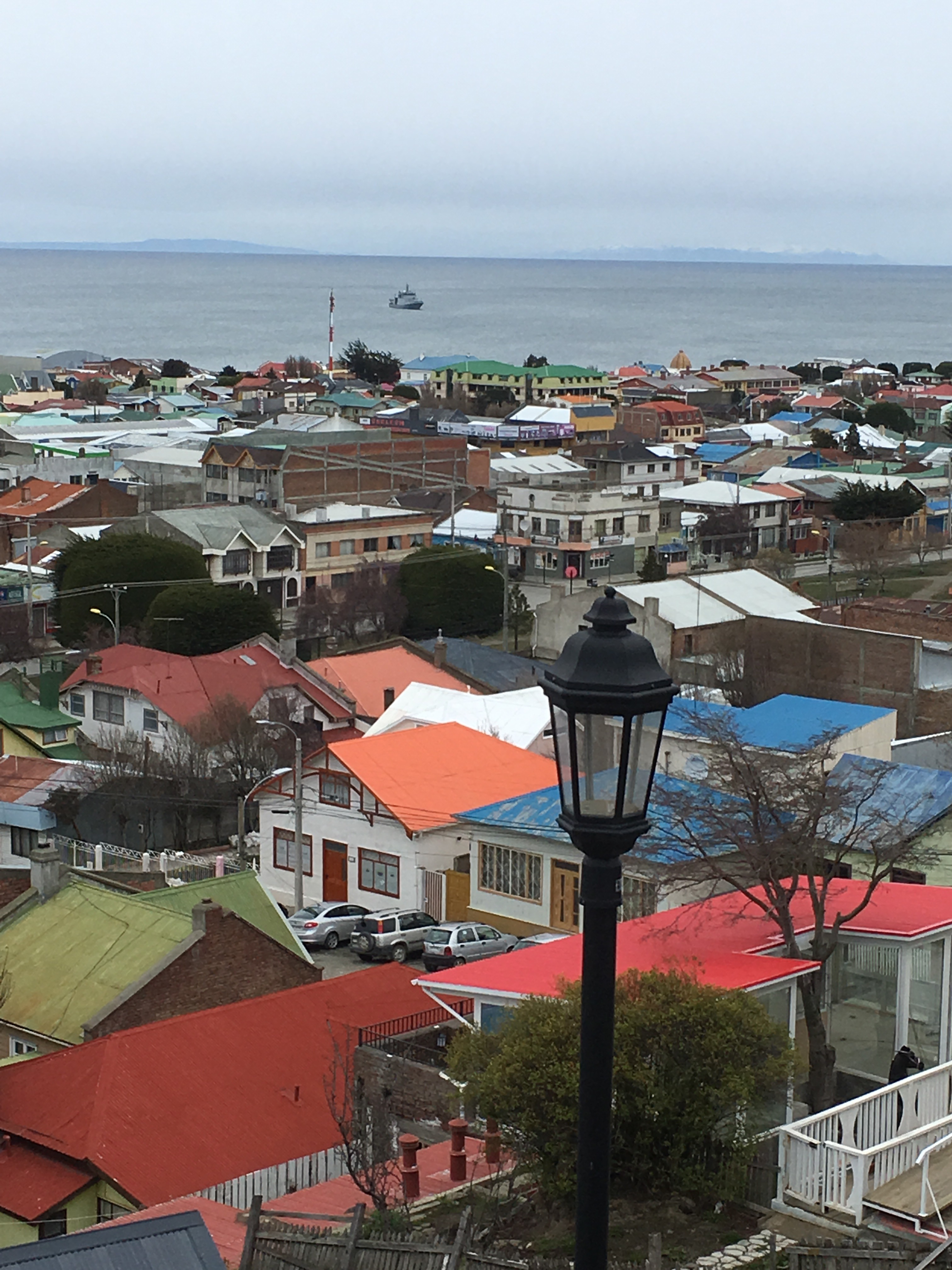
Ushuaia is a humble town of 67,600 people nestled in the mountains and surrounded by the Tierra del Fuego National Park. We stayed in Los Nires Hotel up in the hills. Normally, it costs $170 per night, but with some credit card miles leftover we were able to stay for free. It’s long wood paneled hallways and wide windows resembled an old ski lodge. Most guests were Latin Americans on ski vacations with their families.
Our morning view provided a panorama of colorful facades framed by towering majestic mountains overlooking the village. At the included buffet breakfast of yogurts, cakes, croissants, jam and cheese, we could stare out the large windows and see the blue canal hugged on all sides by more mountains. Every direction you look in this town you see snow capped mountains towering over you.
From the hotel you can walk down to the canal and skip rocks on the stone beach or hang with the many friendly dogs running along the water. There´s a man¬made walk way out on to the water to take in the views. We couldn´t stay long, because we wanted to catch the provided shuttle bus into town to explore.
The town is reminiscent of ski resorts in Colorado. There are souvenir shops, outdoor outfitters, pubs serving Patagonia Austral brewery beer, and people here for winter tourism. The waterfront is more of a marina for colorful sailboats, decommissioned naval ships, and catamarans as well as cruise ships taking tourists on tours of the Beagle Channel and to Antartica.
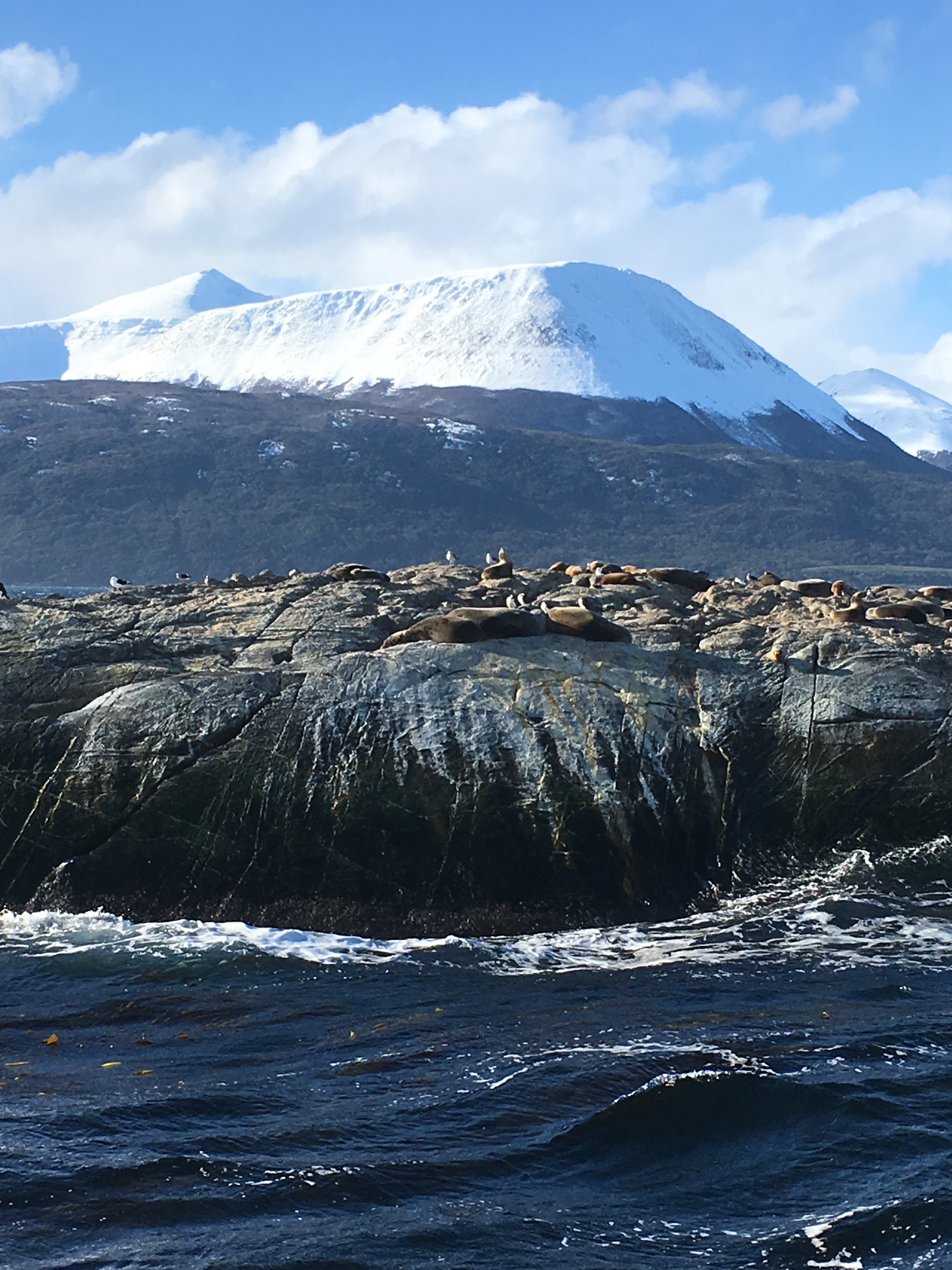
We were convinced last minute to take a catamaran tour. So for $88 total for both of us, we boarded the two level boat that toured us around the Beagle Channel and crossed between the Atlantic and Pacific Ocean that meet at the bottom of the American continent. We stood on the upper deck in the harsh winds to fully experience the tour.
As the frozen air beat against our cheeks, we watched the chain of jagged mountain ranges follow along the water on either side of the boat. We visited several rocky islands along the way, Isla de los Aves and Isla de los Lobos were two of the islands. Both of them provided resting grounds for black and white suited cormorants similar looking to penguins and to boisterous sea lions that barked and bickered and smelled like an unclean cage at the zoo. We also stopped at an island where we could disembark and explore the rugged landscape and the panoramic view of the mountains. The other island housed the weather¬worn red and white lighthouse. The spontaneous boat trip was definitely worth it for us even if we couldn’t see penguins, which are normally an included part of the tours.
We took another tour the next day: El Tren de Fin Del Mundo (the train to the end of the world). This old steam train replicates part of the journey taken by the prisoners who were the first residents of Ushuaia and took a train to the Tierra del Fuego National Park to cut trees to help build the new settlement. They were promised that they could have a home there for them and their families at the end of their sentences. The original inhabitants, the Yamana people named this land and its bodies of water. Unfortunately, there is only one Yamana woman still alive and the rest of her people were killed off by the diseases brought over by European explorers and war over their land.
We rode the steam train to the end of the line and then took a tour bus through the national park. We visited several lakes and drove through the dense forest. The time of year though left trees still at the end of their hibernation with very little green buds emerging for spring. The sky hung heavy and gray over everything, sprinkling flurries here and there. Clouds obscured the tops of mountains and ridges and the lakes reflected this darkness. We enjoyed our winter tour of the vast lush area. It would definitely be worth a visit in spring, summer, or fall as well.
All in all, we really enjoyed Ushuaia despite our timing. The mountains filling the horizon with majestic sightlines provided endless cheer for me. I could stare at them for hours. I don’t regret visiting in the winter to see the glorious white snow caps. It was worth it! It only makes me want to visit again in the summer next time.
Isla de Los Lobos:
Lighthouse: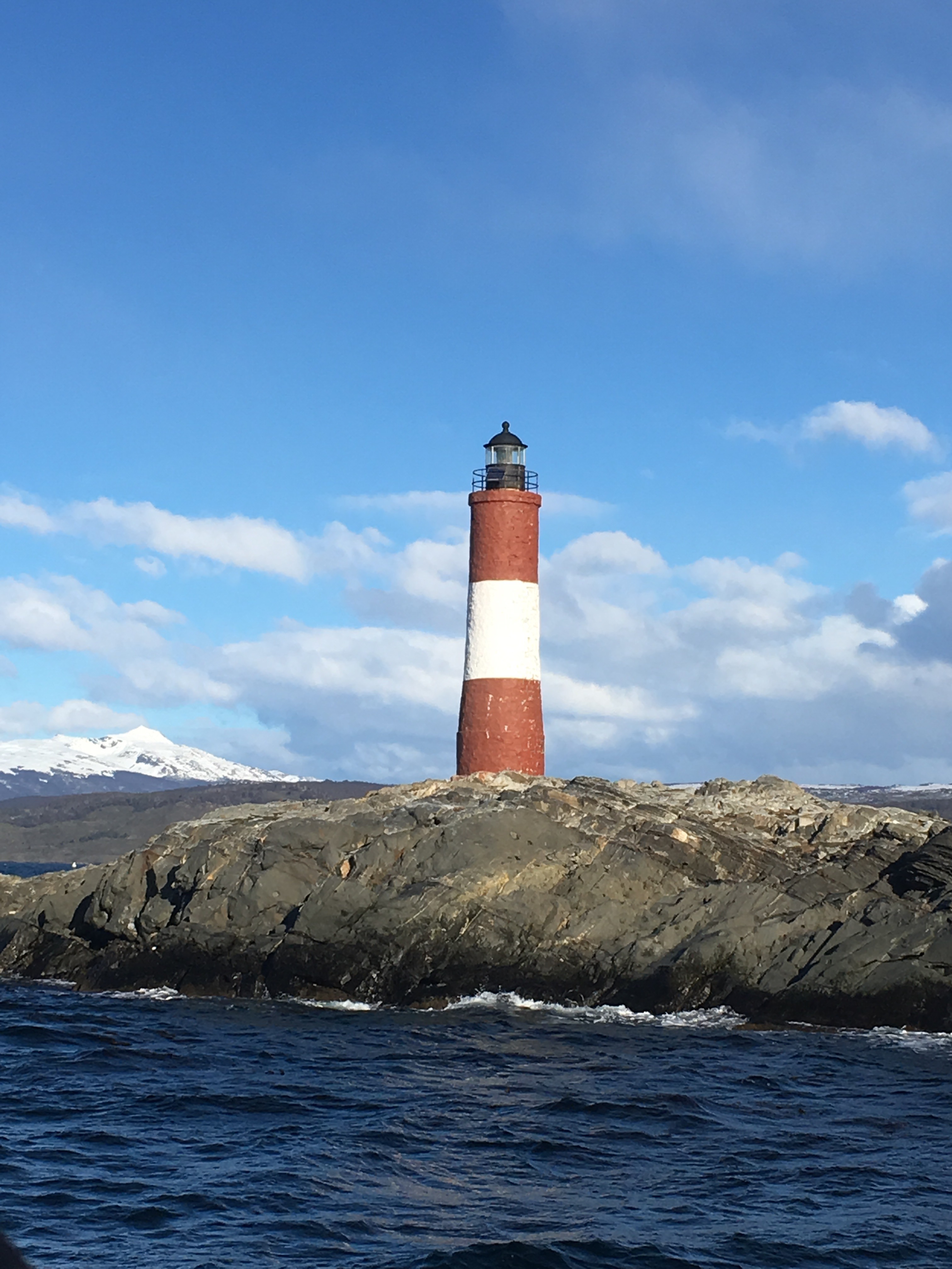
View from our hotel room: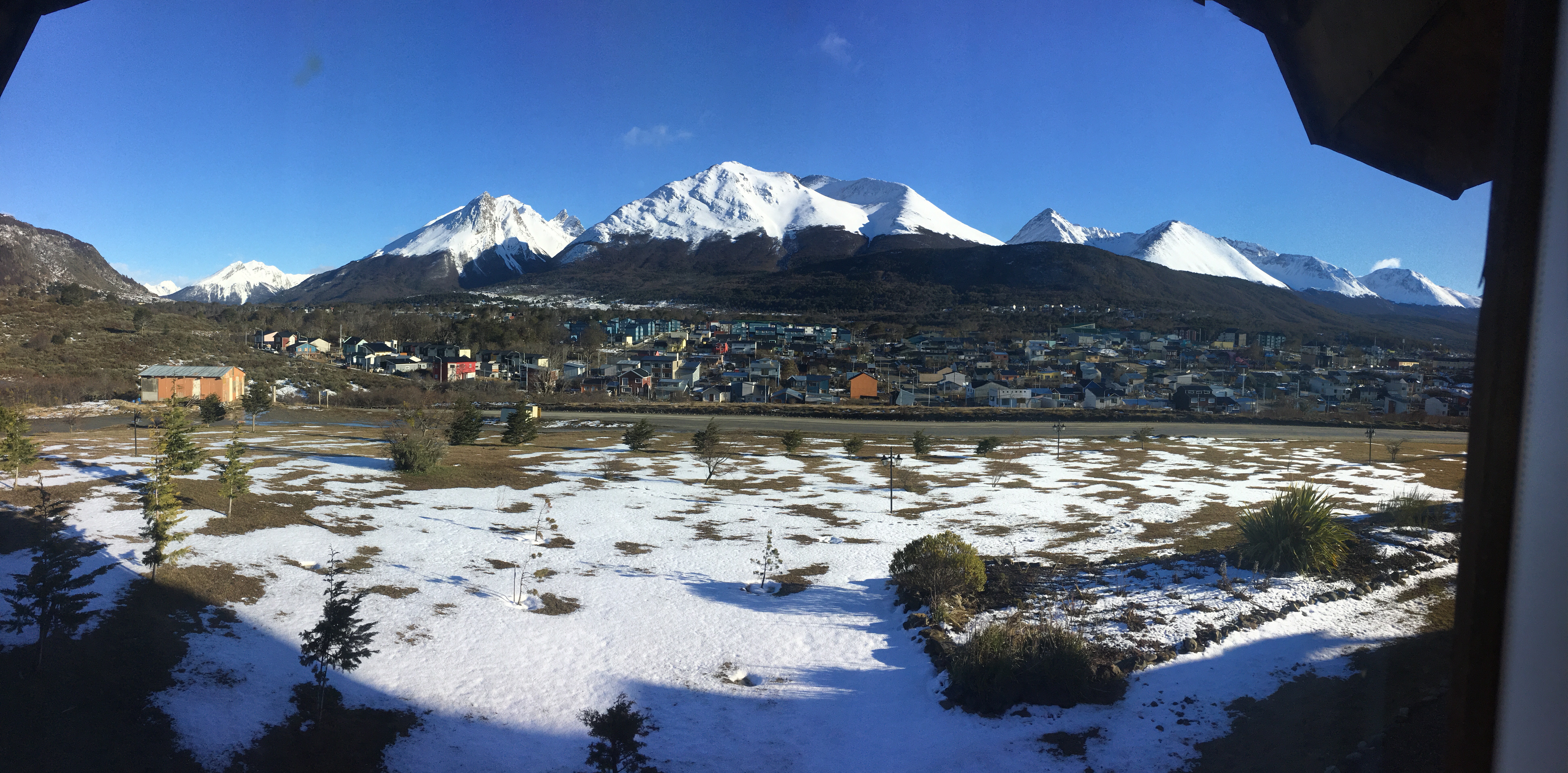
Punta Arenas, Chile:
After a 10 hour journey from Ushuaia via bus and ferry including a border crossing with two checkpoints, we arrived in Punta Arenas, Chile. The town is also in the Tierra del Fuego region shared with Argentina. The town of 170,000 is modest and it’s main attraction is the tours to the Isla Magdalena to see the penguins in late October. Outside the penguin tours, there isn’t a whole lot to do in this town.
We arrived on the second day of Chilean Independence Day celebrations, so all the shops were closed and most of the atms were out of money. Our Airbnb was also a long walk from the center of town. We used the three days here to just rest, catch up on sleep, do laundry, and write in our journals.
Our hosts were friendly bachelors. We did wander around the town and explore what it had to offer. There is a nice mirador, viewpoint, overlooking the city. You can see over the colorful houses and buildings out to the sea. The skyline is mostly low with a few tall buildings that stand out. One of them is a bright yellow steeple from a central church. You can even see the mountains in the distance.
At the center of town is a nice square, framed by cathedrals and government buildings. Most of the architecture in the town is beautiful and old. There are many monuments to Magellan, the Spanish explorer that discovered this part of the world and to the slaves he brought with him and indigenous people of the area. A lot of the statues feature mermaids swimming in front of the ships.
You can explore the whole town in one day. I suggest only visiting when you can visit the penguin colony. It is a very cute town and the people are friendly, but there isn’t a whole lot to do. It’s worth stopping over for a night though on your way to Puerto Natales to break up the long journey. 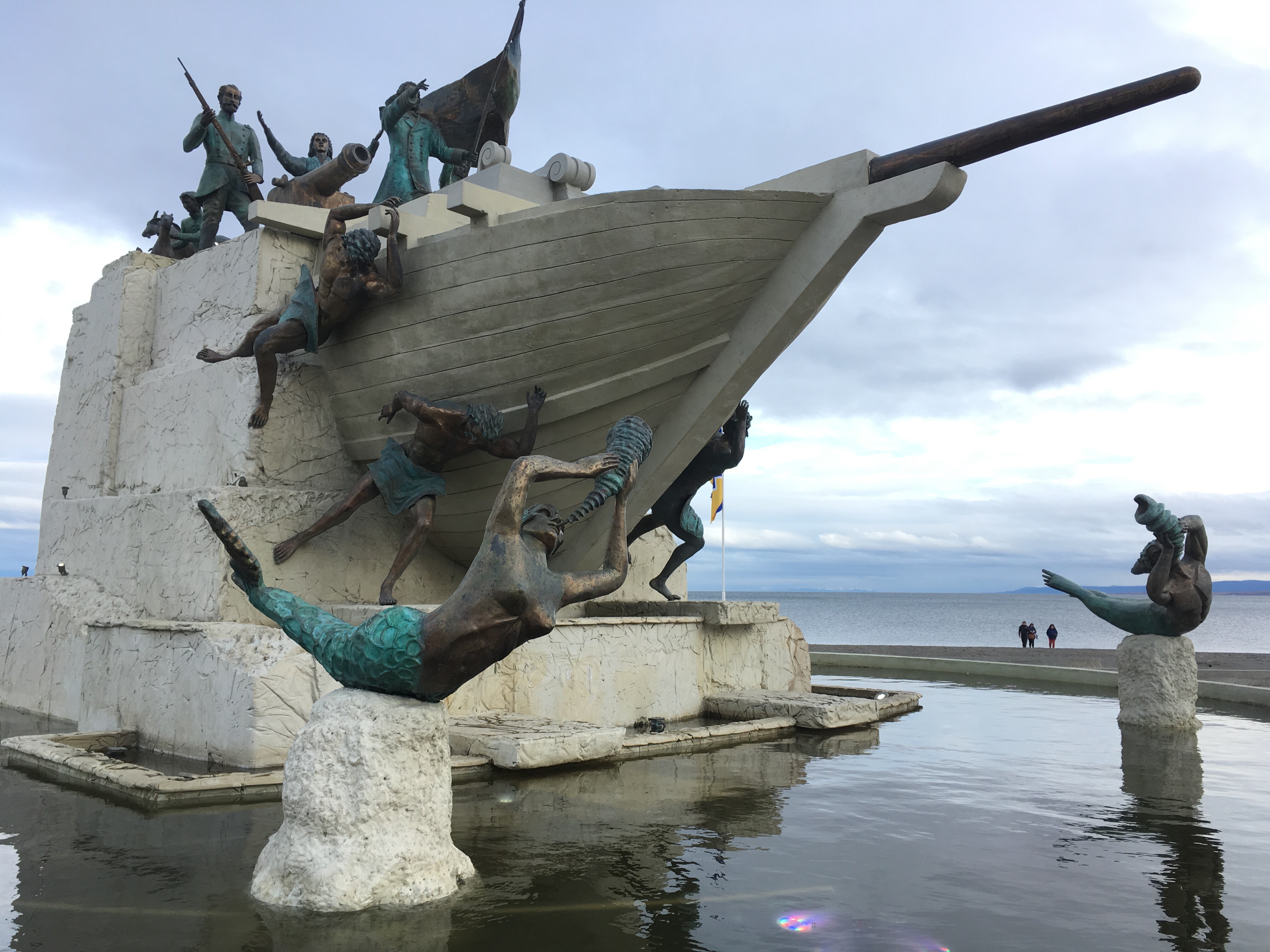
Puerto Natales, Chile:
Puerto Natales is the gateway to one of the most famous parks in Patagonia: Torres del Paine. This National Park is known for its Circuit and W treks (shape of the trek) around the park. They are tackled each year from September to May by adventurous individuals from around the world. Puerto Natales serves as the hub for gear rental, supplies, and booking tours to the park.
The town itself is a small outdoor enthusiast mecca of 19,116 inhabitants with everything you need to visit the park. In the town there is very little to do besides stroll along the waterfront marina checking out the various artistic statues. There’s a big metal replica of the Mylodon, a prehistoric sloth-like creature, believed to have lived in this area during the ice age. Five stone fingers emerge from the sidewalk by the water, a creation of a Chilean artist, and people love staging photos with the fingers. There’s also a stone statue of a native man and European explorer shaking hands to make a deal over the land. Next to this are a soaring man and woman weather vain swaying with the harsh winds over the bay and a skate park.
Due to harsh weather conditions lingering from the end of winter into early spring, we opted out of the W trek. The trek takes 4-5 days and requires either booking expensive refugios, that are rustic lodges within the park, or renting a tent and carrying all gear and food into the park. We didn’t have the money or the desire to sleep in a tent in below freezing temperatures, so we opted for two full day tours- one full day trek up to the base of Torres del Paine and a bus tour around the rest of the park.
The tour started at 6am and took about 8 hours to complete the up and back 8-mile trek to the top. This trail is usually completed before sunrise on the last day of the W-trek, that starts at Glacier Grey. We paid our 11,000 pesos ($17) that is not included in the tour cost of 38,000/person ($59) to enter the park, which goes up to 21,000 pesos ($33) after Oct. 1st.
On the way into the park we spotted a puma that darted across the road in front of our van. The driver slammed on the breaks as it stopped in front of us then took off across a field. They are rare to see, but more common at the start of spring as they reemerge from hibernation to hunt their main prey, the guanacos. Guanacos are part of the llama family and have short auburn fur, long necks, and big ears. They stand in packs grazing on grass along the roads and hills. Once their carcass is left behind by the puma, the giant condors come to feast on their dead remains like vultures. We saw several of them eating and taking flight in the park.
On the trail, we faced 4 miles of varied terrain and the indecisiveness of the micro-climate within the park. The first 3 hours/miles presented a winding path up and down the side of a ridge with the Paine River flowing to your right below and mountains rising up along the opposite side dwarfing you in their presence.
We crossed wobbly wooden bridges, which held a capacity of two people at a time. The trees along the hills called lenga and nires trees, or desciduous beech trees in English, began to sprout green leaves as spring arrived in the park. Parasitic lichen grew out of the branches like neon green Christmas ornaments bringing color to the dark drab forest. They called it mistletoe. We could see the forest waking up to this new season and stretching its well rested limbs for a rebirth.
The weather conditions had not caught up with the memo of spring yet as every five minutes it changed drastically from sun to harsh winds and rain that smack you like a wet whip across the face, then came blustering snow and finally it would clear back to sun again. We all removed and replaced layers of clothing every few steps. This continued all the way to the top and only got worse the higher we climbed.
After the first three hours of winding along flat dry trails to windy narrow ridges that taunted your limbs into toppling down the hill, and wooded paths, we reached the last hour and mile ascent to the top. We were warned this was the toughest part of the trek and that was an understatement.
From this point forward we scaled uphill along a babbling brook, hopping, skipping and jumping across and up wet boulders and slippery rocks. The ascent felt never ending. My quads began to burn as the only thing helping me lift myself on to the next rock was my trekking pole not my tired legs. Water rushed into our shoes soaking our socks. We climbed and climbed.
Then the brook turned into a crumbling gravel hill that slipped out from under you. That transformed into a snowy ice field at a 85 degree angle. We haphazardly skated across the snow and ice, grabbing boulders for balance as the harsh wind knocked us sideways and thundered in our ears. We stopped to look up and witness the mastiff of the three jagged towers beckoning ahead of us and the cathedral of snow capped mountains at our backs. We felt like the hobbits in Lord of the Rings on a quest to return the ring.
I kept repeating in my head “un poquito más” (just a little more) and before I knew it we turned the corner to reveal what felt like the gates to heaven opening before us with the sun glowing bright and the choir of angels singing as we arrived. I’m not religious, nor do I even believe in heaven, but this moment felt like something otherworldly and a true hint at some kind of god.
Here we were standing at the foot of three jagged stone spires haloed by wispy clouds and at its feet a nuclear aquamarine lake glowing like something from another planet. Every hard climb in life should be rewarded like this. My jaw dropped and a tear slid down my cheek. How in the world is this real!?
We stared for a good half hour at the magnificent and terrifying beauty of this creation of nature. The rocks tumbling down its wide mountainous arms thundered as the sound echoed across the lake. The bitter cold winds stung our cheeks and froze our sweaty backs. We added all of our layers back on.
The descent wasn’t nearly as rewarding, as I hobbled from a tight IT band and daydreamed about the Torres del Paine. Most people believe this means towers of pain after they complete the painful trek, but Paine actually stands for the color blue of the glacial lakes and rivers in the area and is an indigenous word.
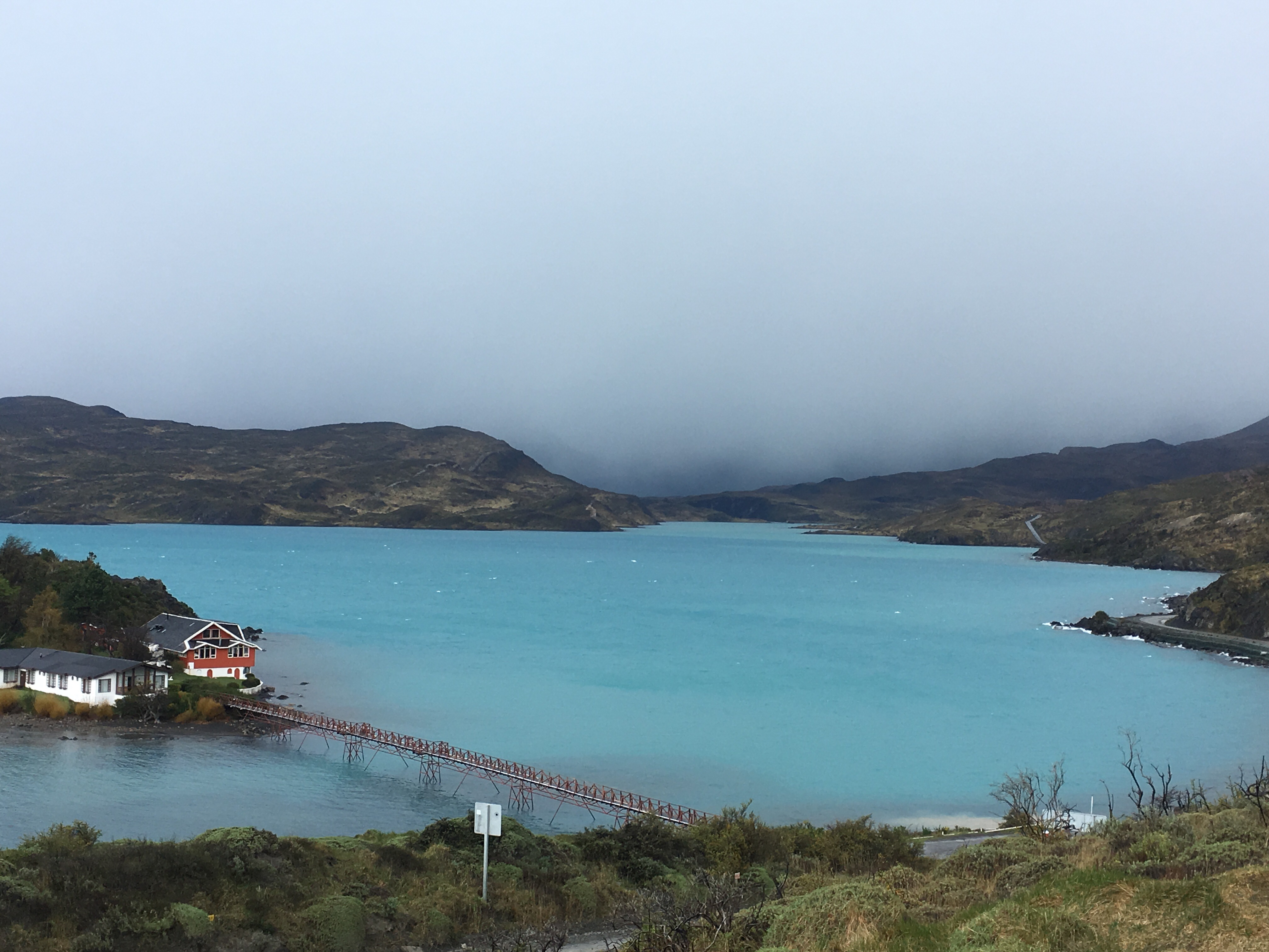
After this trek, the tour around the park just didn’t compare. We visited all of the glacial lakes- Sarmiento Lake (the 90 km2 lake that covers most of the park), Nordenskjold Lake (named for its Swedish discoverer), Pehoe Lake (that has a little island with houses at the center), Laguna Armaga (that holds many minerals and is extremely salty), and Grey Lake that starts the treks and has a glacier and icebergs floating on its bright blue water.
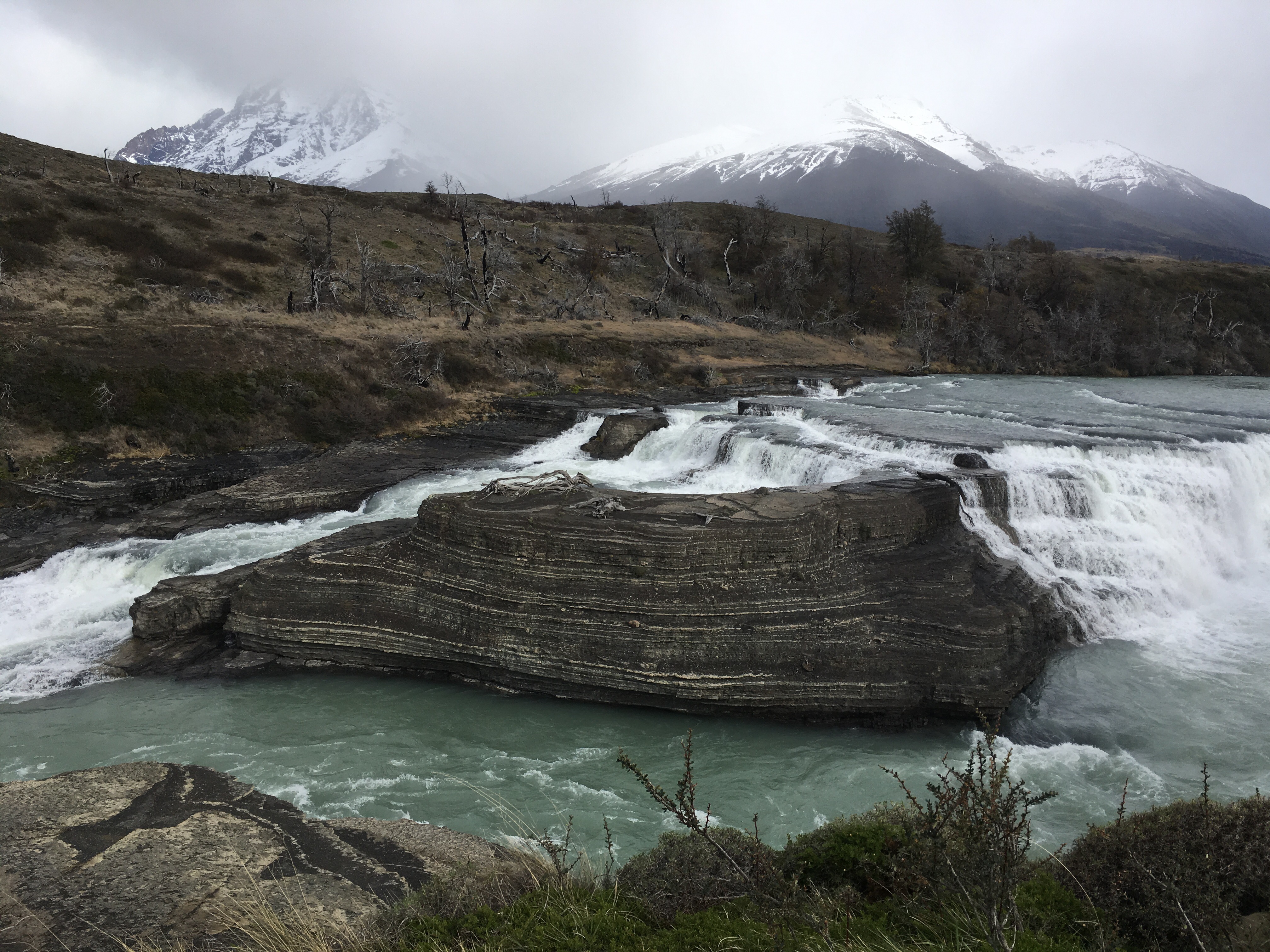
We visited a waterfall called Salto Grande that emerges in the middle of the Paine River that runs through the entire park. The water rushes over a winding shelf of rock formations in the river, causing a loud crashing of water as it pours over the edges and fans out across the rock face. We could not see the second waterfall, because the weather picked up and the heavy rain, sleet, and snow made it unappealing to leave the heated van.
We also viewed a lot of the local flora and fauna in the park. We saw groups of guanaco grazing in the fields, condors preying on dead rabbits, Patagonian ostrich with their stick legs running awkwardly, woodland deer that approached us for food, and Patagonian geese that are always found in couples with the white male and brown female. Our guide told us the geese mate for life and if the female dies the male dies soon after, but if the male dies, the female finds another mate. The guanacos tend to have an alpha male in each pack that has many females that travel with him. We did not see any pumas, known as mountain lions in the US, on this day but we saw two the day of the trek.
This park is magical and well worth the money to visit whether you do the full circuit around the park for 9 days, the 5 day W or just pay for full day tours. Winter is beautiful for snow capped mountains with snowy waterfalls cascading down the rock faces. Spring brings wildflowers in the park. Summer presents warmer more pleasant trekking conditions with lush green hills. Autumn sets the hills into a fiery red as the foliage changes colors. You really can’t go wrong.
Lake Pehoe:
Salto Grande Waterfall:
Guanaco grazing in the fields: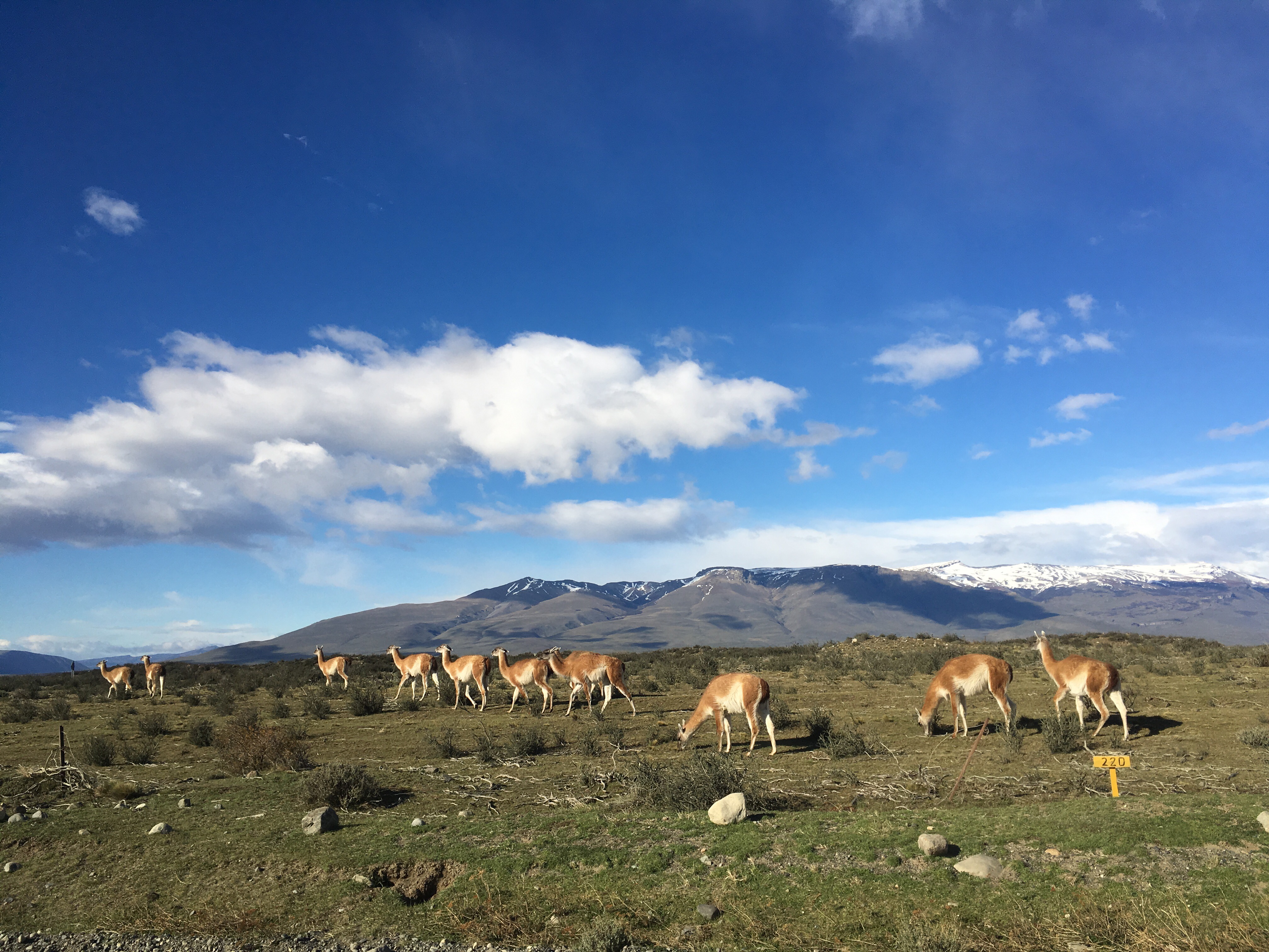
The base of Torres del Paine: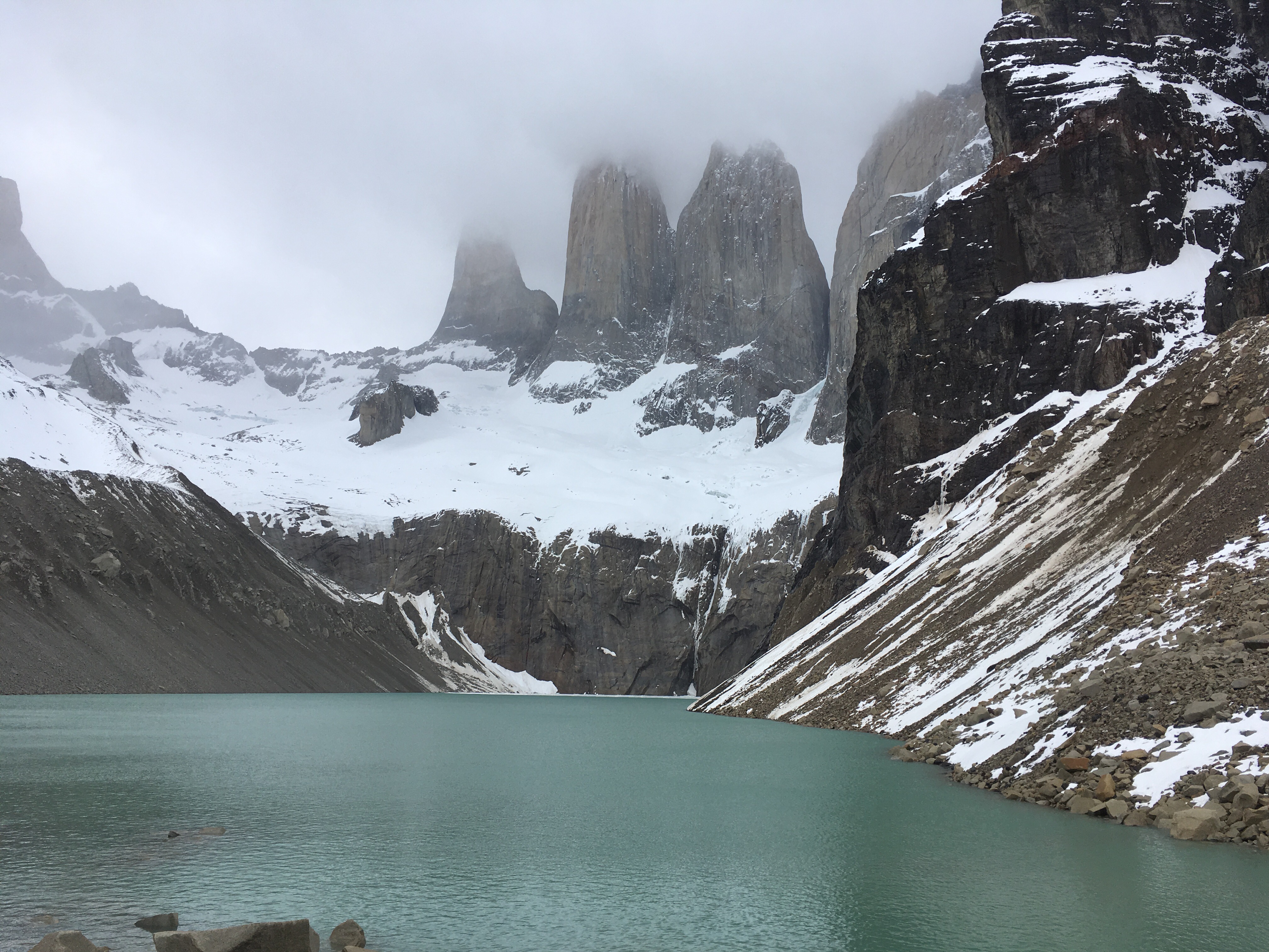
El Calafate, Argentina:
This Argentinian town 5 hours north of Puerto Natales is a small town of only 21,000 people. It’s main attraction is the Glacier National Park that houses the biggest growing glacier in the world: Perito Mereno.
You can visit the glacier on your own by bus for 450 pesos ($25) or with a guide for 650 pesos ($36). If you are looking for more adventure, you can trek on top of the glacier with ice picks and crampons for 3200 pesos ($180) or for even more money you can do the big ice tour, which involves longer trekking on the ice for 5600 pesos ($318).
We opted for the cheapest option to just catch the bus at the station and explore the glacier on our own. On top of all the tour costs, you must also pay a 500 peso ($28) entrance fee not included in any tour cost. The entrance costs to these National parks really add up. For another 500 pesos you can take a boat up to the glacier.
We walked to the bus station from our hostel and hopped on the mini bus at 9am. The ride was about an hour and a half from Calafate. You drive along the beautiful Lake Argentino watching the Andes mountain range reflecting its white-capped pyramids in the deep blue waters. It was hard to capture a picture out the windows that fogged up from the excessive blasting heat in the bus.
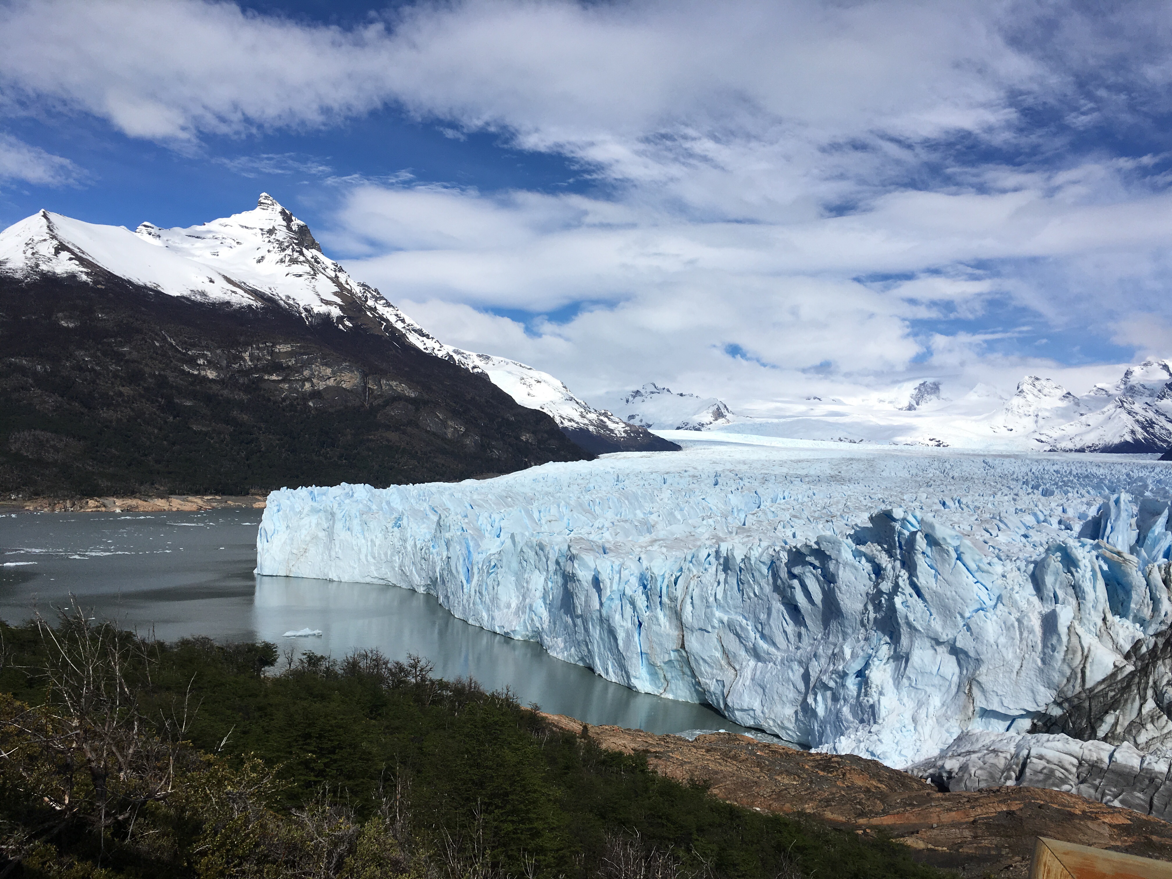
A road block stopped the minibus and two guards popped into the buses to collect the entrance fee into Parque Nacional Los Glaciares. Then the 175 ft. high glacier appeared in the foreground framed on all sides by blue and white mountains. We all scrambled for our cameras as the view switched sides with every curve of the road.
The driver parked at a restaurant for us to use the facilities one last time before entering the park. Once at the park, there are several wood/metal raised paths to choose from. We started with the green circuit through the mossy peaceful woods, then veered off to the left along the less taken red path that visits the far left end of the glacier. This path then joins the yellow circuit and finishes with the blue back to the restaurant, where we were told to meet the bus driver at 4pm, giving us 5 hours in the park.
Each path provides several platforms from different heights in order to view the glacier. There is a black path for handicapped access. You can complete all of the circuits in under 3 hours. This leaves a lot of extra time for staring at the glacier and waiting for the thunderous calving of ice.
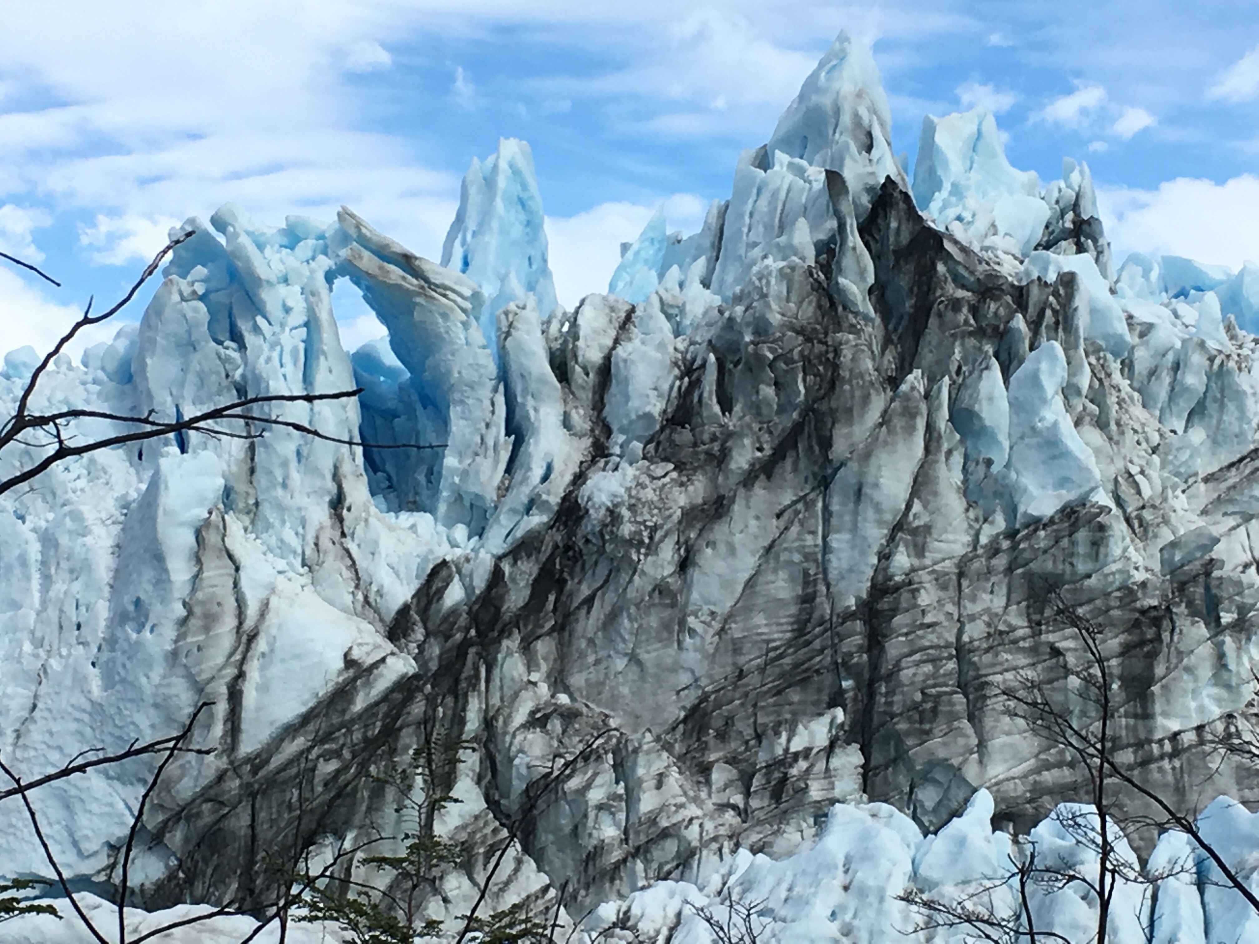
Perito Moreno glacier is so impressive, because it is 240 feet high at the highest point, 3 miles wide, 19 miles long and has an area of 97 sq miles. From the lowest path, you truly feel the enormity of this growing glacier. You feel like an ant staring up at the Empire State Building. It doesn’t stand much shorter than the mountains surrounding it. Viewing it felt humbling. Then you hear the echo of what sounds like a cannon erupting and realize it’s the sound of ice calving off the glacier and crashing to the lake below. When a large enough chunk of ice calves it causes a huge ripple effect in the water and sends a wave across the lake.
We could have watched this glacier for hours, anxiously anticipating more ice to fall like a gunshot across a peaceful forest that rattles the environment sending birds chirping and taking flight. Along the red trail, there aren’t many other tourists, so we could experience the glacier in complete silence and feel at one with nature. It’s blue peaks and valleys glistened in the sun. The sound of rushing water filled the silence coming from within the nooks and crannies of the porous glacier. Sometimes you would here the thunder of calving, but be unable to locate what fell and where.
There’s only so many pictures you can take of the enormous glacier before you realize none of them truly do the experience or seeing it firsthand justice. So we sat on a bench and just watched it’s pure beauty in peace and meditation.
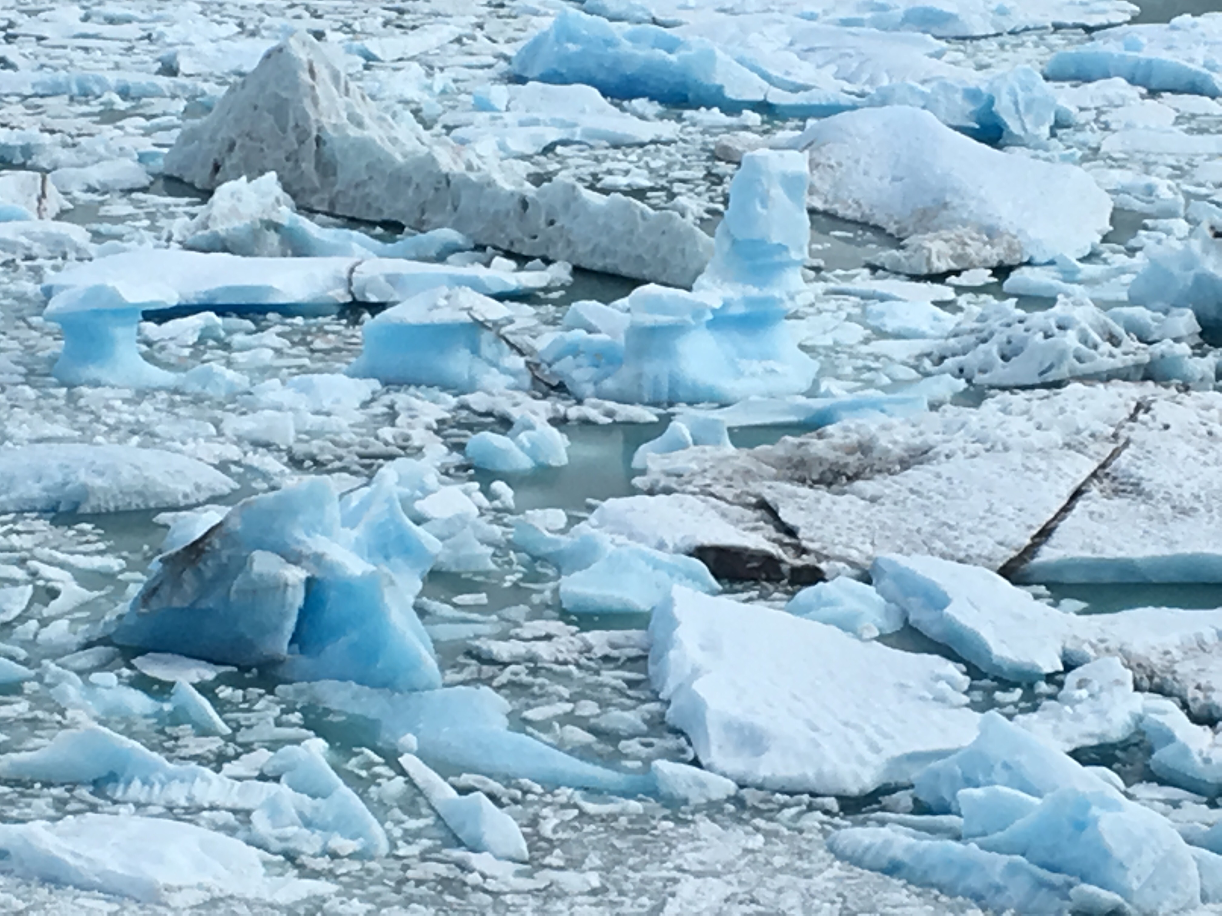
Unfortunately, five hours is way too long for viewing the glacier, so we killed a lot of time just watching this living breathing testament to the ice age. We did not take the boat, but could see it slowly traversing the lake to get a closer view of the humbling ice towers. At this time the ice has grown on to the land and closed the channel between the Argentino lake and its major arm called Brazo Rico. In the summer, this growing section of ice calves off and reveals the canal. At the moment it is completely severed by the ice and is surround by bobbing icebergs in the frosted water.
No matter what way you choose to experience the glacier, it is definitely worth it to see it in your lifetime.

El Chalten, Argentina:
After a short ride from Calafate, we arrived in the trekking mecca of Argentina, called El Chalten. It is very close to the border of Chile and though the two countries desputed over its ownership, Argentina quickly built this small town of 1,500 people in 1985 to claim the area as its own. It was well worth their time, since the area around El Chalten is truly magical and is one of the only places in Patagonia where you can trek and camp for free just a short walk from town. It is also home to the iconic mountain range, Fitz Roy mountain, that serves as the logo to the Patagonia Outdoor Clothing and Gear Company.
You can tell the town is still in development, as many of the buildings are still under construction and there is really a lack of infrastructure in the town. There is only one atm and it is at the bus station, but it rarely works even though the town functions solely on cash. So, bring your cash from Calafate or you will be stranded here. There is also only one grocery store and it doesn´t carry much options. We were forewarned, so we withdrew cash in Calafate and bought all of our groceries there. Also, don´t expect a good wifi connection in any of the hostels as it is all fed by sattelite and is oftentimes down. For such a beautiful town, it still appears to be undiscovered by much tourism. In the winter and up until late November, the town is really dead and most restaurants haven´t opened yet.
We spent our first day stuck inside the Patagonia Hostel, due to rainy weather conditions. Since the only thing there is to do in this town is hike, rock climb, and kayak, rain makes for a boring day inside. Luckily, on the second day, which also happened to be my 30th birthday, I was gifted with a beautiful sunny day from the Universe. I could not have asked for a better gift. This freed us up to tackle the main hike in town to the mirador of the Fitz Roy mountains and the Cerro Torre mountains, an 8 hour hike.
In order to get there, you can either hike up and back along the same trail near town, or for more varied sight¬seeing, you can catch the shuttle bus from Patagonia Hostel for 160 pesos each ($9) to the Hostelria El Pilar at the start of the trail to the top and then take the other trail back into town. This way you see different views on the way up and down. The scenery on the way to Pilar, had us wanting to dive out of the moving van to snap a picture of the white mountains that looked like chocolate cakes with a heavy dusting of powdered sugar. Ponds reflected the world upside down and condors soared overhead. This landscape is a photographers paradise.
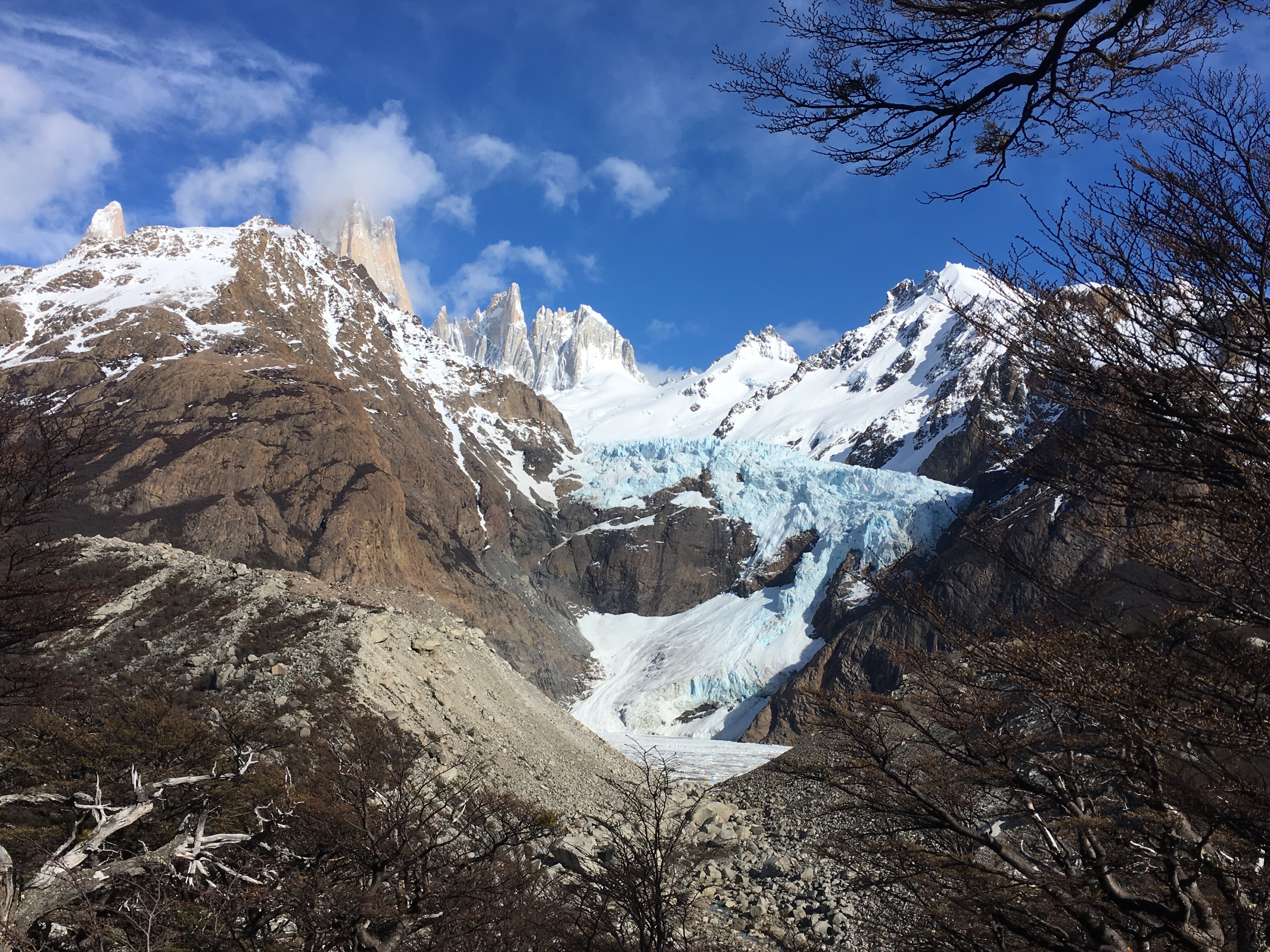
When the driver finally pulled over, we eagerly hopped out with our cameras ready to capture the day. We could already see the silhouette of the Fitz Roy and Cerro Torre mountains beckoning us in the distance. We joined a couple from our hostel; the guy was Australian and the girl was Dutch. The trail had only a little elevation gain throughout the first 3 hours and provided multiple viewpoints to see the mountains as they revealed their jagged set of teeth. Their unique spires were like the chiseled edges of stone arrow heads cutting through the clouds.
There was even a glacier resting in the crevace between two spires, shining blue and bright in the distance. They called this the piedras blancas (white rocks). We stopped among a group of Chinese tourists to catch a picture, before entering the dense forests ahead. The forests carried a heavy ominous feeling like a tree battlefield where the trees went to war with the elements of nature and lost by the hundreds. Their bodies lay strewn across the muddy expanse, piled on top of each other for lack of space. Their surviving friends had missing limbs and broken arms and fingers. Cows plodded through the remains in search of food. It was depressing walking through this graveyard of trees. Trees 0, Elements 10.
We crossed several wooden bridges over winding milky rivers. The landscape metamorphised into a new environment every quarter mile. We came upon a long stretch of high desertland with dehydrated soil and brittle porcupine¬looking shrubs. Water filled in the gaps between the shrubs, leaving shallow puddles reflecting the blue sky and white puffy clouds. The path led back into the woods where tents were set up on the flat cleared land.
We carried on across another wood platform over a snaking river, then the elevation began to climb, announcing the start of the last hour ascent to the mountains. The trail got harder and harder the higher we climbed. First it was well groomed trails, then there were large rocks to mount and jump across, then the whole trail was covered in snow and ice. We tried our best to avoid stepping on the slippery snow and to go off the path on to the gravel. It appeared that the snow only fell on the designated trail and the whole area around it was untouched by white. Even the gravel slipped out from under our feet and crumbled towards the person below us. We had to really concentrate and watch each step we took with caution and purpose. The guys moved quickly, while me and the Dutch girl took our time, methodically choosing each step, so that it wouldn`t be our last. I wanted adventure on my 30th birthday, not for my life to end prematurely.
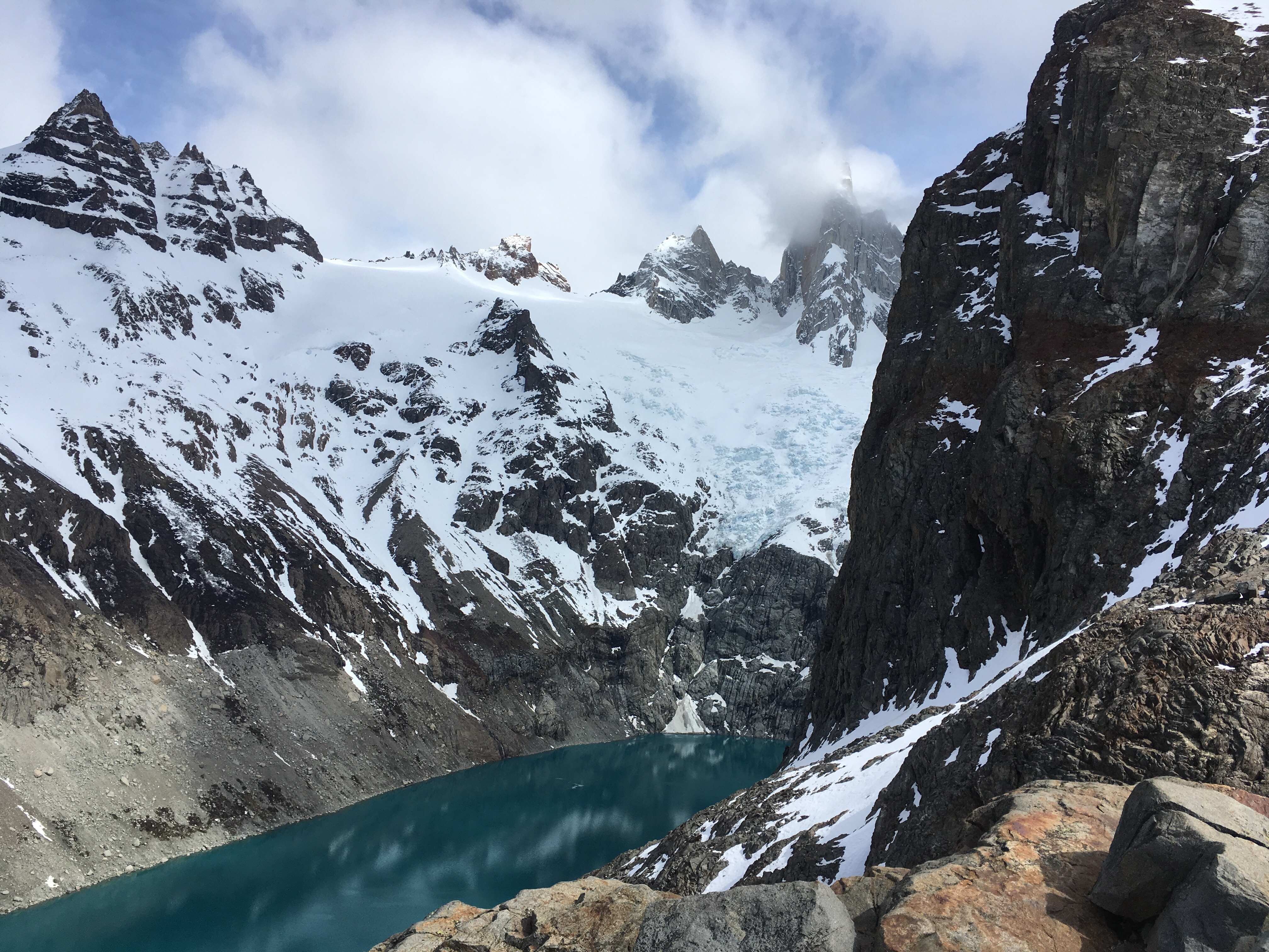
Thankfully, we made it to the next landing alive, and felt disappointed to find that our climb to the top was not quite over. We had to scale up another snowy hill. We took our time again, being egged on by our partners, who found it easy. Finally, we reached the top and could stare our target in the eyes as it bared its teeth from beneath the wispy clouds. At this time of year, the lake below is frozen over and covered with snow, so it completely disappears, but you can head down the otherside of the hill and up a ridge or around the ridge to see a spectacularly vibrant teal lake in the armpit of the mountains.
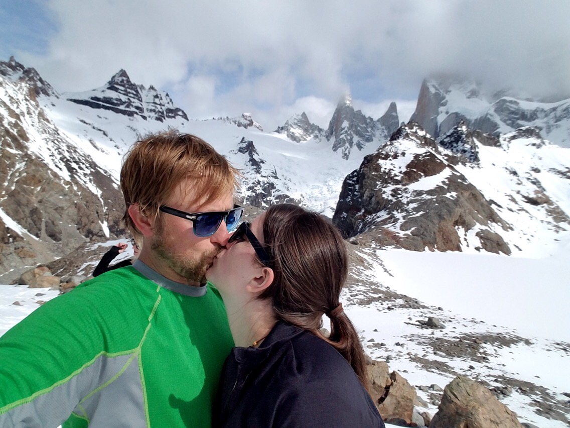
We snapped a few victorious pictures at the top viewpoint with the jagged mountains behind us before heading for the other lake. After sliding down the snow and plodding across the frozen lake, we found the teal waters that surprisingly stayed clear from snow. Lunch filled our bellies, while winds whipped up a new batch of snow and rain in our faces. It was time to go back down, especially since the clouds decided to sink lower and obscure the entire view of the mountains teeth.
The descent proved to be the hardest of all as we slipped and slid across the ice and snow, watching as our feet tempted the scary edge. My knee acted up as usual making it extra difficult to climb down. I took my time though and after an hour and a half of death¬defying steps, we reached solid ground and almost kissed it. The trail home was mostly flat as it carried on along the ridge of the mountains. We turned around periodically to peer back at the mountains that now freed themselves of the clouds except for the small hat worn by the tallest peak. It looked like that peak could go up into the sky for miles like Jack`s beanstalk leading to another land full of giants. We couldn`t stop taking pictures and looking behind us to see it once more. We even detoured to Lago Capri (lake) to catch a view of it over the wind swept surface of the waters.
Eventually, we made it through the dense forests, sandy beach lakes, and dry red ridges to the town of Chalten again. I felt spent and alive at the same time. I was proud of my accomplishment on my 30th birthday and ready for a drink to celebrate. Lucky for us we made it back to the hostel just as a heavy gust of wind carried in a storm from the mountains. We had to run through the rain to the bar for a celebratory drink and only lasted through one before heading to bed. Sadly, we left the next day knowing we were missing out on many more free trails to explore and another sunny day, but now we know a place we must return to one day.
Piedras Blancas:
Top viewpoint of Fitz Roy: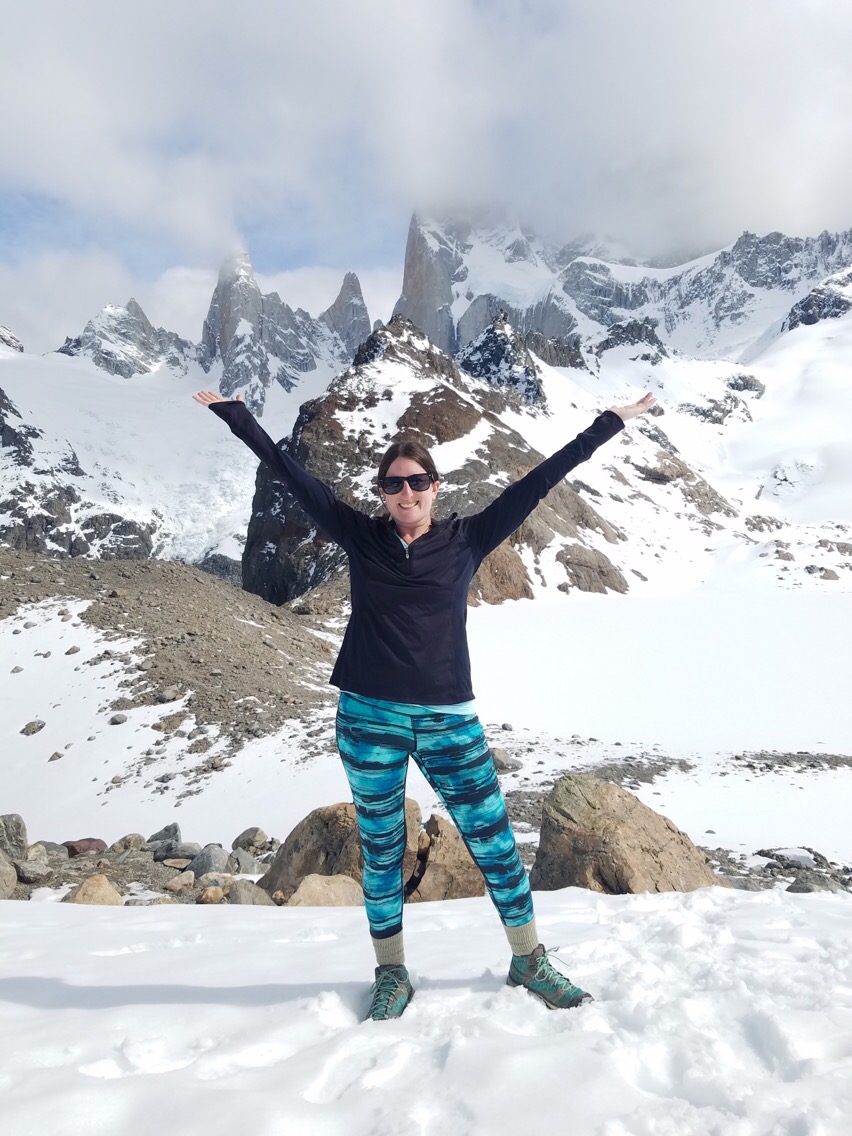
Despite our bad luck with weather, Patagonia was well worth the visit and we are already planning another trip back. We have never been so amazed in our life by such rugged landscape and outstanding adventures. We are yearning for more! Now we are off to the nothern part of Patagonia known as Rio Negro Lake Region. We are going to miss the south and hope to see it again someday, possibly in better climate.
